
The evolution of technology and the developing of new areas in the tech world such as: robotics, machine learning and deep learning made some machines and existing technologies feel old and outdated.
The main problem with GPS is that it requires a connection to four satellites and in case it loses connection to one of them then we will get results that are very inaccurate. This could happen if we use the GPS in a closed or secluded space. In addition, GPS requires a lot of power and resources thus making it costly. All of this combined made the need for an alternative to the GPS much needed.
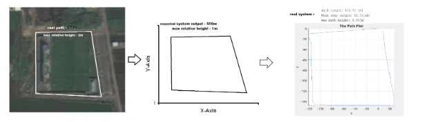
Our project uses the existing acceleration and orientation sensors in our phones in order to record this relevant data while walking. The phone is strapped into the user’s chest while doing the path and the data is recorded while he walks the planned path. The recording is done using a very user-friendly free app called sensor logger and the results are saved into CSV files and then used to draw the walked path offline right after.
Upon receiving the CVS files into a computer, they go through a MATLAB system which extracts and cleans the data and then pinpoints the steps that were done whether they are: steps forward, steps backwards, an upstairs or downstairs. In the next part the step sizes are predicted and then all the collected data is used in order to draw the path.